I am an ordinary guy who enjoys riding motorcycles. I love riding all makes and models. I love short rides, long rides, and multi-day road trips. I post reviews about motorcycle gear, motorcycles, roads, restaurants, sights, gadgets and more. The Motorcycle Facts,Trivia and History page has a lot of good info. Be safe and enjoy the ride, Oz.
Showing posts with label vista. Show all posts

Tuesday, January 7, 2025

Epic views from National Scenic Byway - Beartooth Highway


View from Beartooth Highway  

I love mountain air and the amazing vistas.  I enjoy looking out in all directions and seeing miles of valleys, mountains, lakes, and wilderness. Some mountain passes are breathtaking.   I take a lot of photos even though the photos never capture the awesome beauty.

On my trip to Yellowstone and again on my trip to Alaska I made plans to ride US 212 a.ka. the Beartooth Highway that connects Montana and Wyoming by way of Beartooth Pass.  The Beartooth Highway is designated an "All-American Road" which means the US Department of Transportation deems the road worthy of being a tourist destination unto itself, due to the scenic uniqueness.  Of the 150 National Scenic Byways there are only 37 roads with the distinguished All-American Road designation and this one is well deserving. 

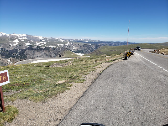
Top of the pass in late June - no snow or ice on the roads luckily
 
The  Beartooth Highway runs 67 miles from Red Lodge, MT to Silver Gate, MT (northeast gateway to Yellowstone NP) crossing the MT/WY state line twice.  The 38 miles stretch between WY 296/ Chief Joseph Highway (another great road) and a point about 12 miles west of Red Lodge, MT is the most scenic, invigorating, and challenging portion of the road.  The road has breathtaking vistas, hairpin curves, elevation changes, sweeping curves and wildlife.

The Beartooth Highway twisting up the mountain
 
The road reaches an elevation of 10,947 ft. at Beartooth Pass.  Cliff hugging switchbacks, tight curves, steep grades, and mountain plateaus make for an amazing stretch of pavement.  The high elevation makes drastic weather changes a constant possibility so riders should be prepared.  When we rode up on July 15 the temperature dropped about 25 degrees from the Beartooth Highway/Chief Joseph Highway intersection to the pass and state line.  We had to stop and bundle up before we got too high.  Glad we did since it was cold and windy at the pass.

Heading towards the pass
 
At the pass and at the MT/WY state line we enjoyed the vast scenery.  It was amazing.  The mountain lakes were deep blue, the peaks were still snow capped, the meadows were alive and green, and the vibrant tundra stretched out around us.  Both sides of the pass are fantastic and challenging. 

 Twin Lakes 
 
 Beartooth Mountains
 
Forest and stream on west side of the pass
 
There is one store along the route known as the "Top of the World Resort."  You can get fuel, snacks, drinks, t-shirts, and souvenirs.  There is also a nice area with picnic tables to sit and enjoy the surroundings.  The staff was very friendly and informative.  We enjoyed a nice break on top of the world.  If one was so inclined the resort has lodging available.

Top of the World store - a great place stop
 
 
The road offers great views and fun curves
 
We hit the pass around noon so the chance to see much wildlife was not good.  We were too late (or too early depending on how you want to look at it).   We did see some bison not too far from the road as we were heading to Cooke City, WY.


Bison roaming near the road - watch out!
 
The Beartooth Highway is a great All-American Road and is well worth the ride.  The beauty and the fun is intense.  If you get to that area of this great country make sure to include US 212.  You will not be disappointed.

Connect and follow Biker Oz on the following:

         https://www.instagram.com/ordinarybikeroz/?hl=en       https://www.facebook.com/profile.php?id=100009663932095
 
Please visit the following great companies:


Ordinary Biker Oz YouTube Channel has video reviews and more


* I have personally ordered from and/or visited these businesses and based on my experiences I recommend this company.  I have an affiliate relationship with the businesses, which means if you follow this link and purchase, I will receive a small commission and will get to ride more!
 
Feedback on these businesses is appreciated.  You may comment below.

Wednesday, September 9, 2015

Loveland Pass ,Hoosier Pass Great riding in Colorado

Mountain roads are fun to ride and many provide breath-taking vistas.  Colorado is full of roads with amazing views, exhilarating curves and high altitude passes making it one of my favorite states to ride in and US 6 south from I-75 to CO 9 south to Alma, Co is one such 44 mile ride.
US 6 north of Loveland Pass

Starting at the intersection of I75 and US 6, near the Loveland Ski Area, US 6 has an elevation of 10,600, but rises as the road twists and turns up the mountain for 4 miles to Loveland Pass at 11,990.
 Video heading up to Loveland Pass from I-70
(turn your speakers down, wind noise is bad)
A convenient pullout at the pass allows individuals to take in the scenic vistas.  On both sides of the road a short walking ascent puts you above 12,000 feet and provides awesome panoramic views of the Rocky Mountains.
West view from Loveland Pass
US 6 south of Loveland Pass

Continuing south from the pass the elevation drops quickly via switchbacks.  In 3.5 miles the elevations drops almost 1,000 feet where a long sweeper takes you past Arapahoe Basin Ski Area.  At an elevation of 11,000 at the base and a summit of 13,000+ the Arapahoe Basin Ski Area is the highest skiable terrain in North America (Arapahoebasin.com).

The next 6 miles descends with gentle curves into the town of Keystone.  At the western end of Keystone US 6 intersects with CO 1 south towards Breckenridge.  The road runs besides Dillon Reservoir and intersects CO 9 about 6 miles north of Breckenridge.  US 9 is pretty straight going into Breckenridge, but the surroundings mountains are beautiful.
Riding pass Dillon Reservoir
Heading south out of Breckenridge (9,600 ft) US 9 rises for the next 9.5 miles to Hoosier Pass (11,542 ft) with some nice switchbacks prior to the pass.  At the summit of the pass is a nice turnout area to park and enjoy the scenery.
 Coming off Hoosier Pass on US 9 south
Leaving the summit there is a 5.7 miles leisurely descent into Alma, the highest incorporated municipality in the US with permanent residents (10,578 ft).  From Alma the road descends for 6 miles to Fairplay (9,953 ft) and intersect with US 285.

This stretch of road is well worth riding.  The views are indescribable and the road is a blast!  Any rider would enjoy the road, the views and the towns along the way.

For some great photos and another riders take on Loveland Pass check out Redleg's blog post - LINK.
 
Connect and follow on social media

         https://www.instagram.com/ordinarybikeroz/?hl=en       https://www.facebook.com/profile.php?id=100009663932095
 
Please visit the following great companies:


https://dukecannon.com/?rfsn=3578014.7da392
Logo 468x120

Ordinary Biker Oz YouTube Channel has video reviews and more


* I have personally ordered from and/or visited this business and based on my experiences I recommend this company.  I have an affiliate relationship with this business, which means if you follow this link and purchase, I will receive a small commission and will get to ride more!

# Based on reviews, word of mouth and discussion with others I recommend this company.  I have an affiliate relationship with this business, which means if you follow this link and purchase, I will receive a small commission and will get to ride more!
 
Feedback on these businesses is appreciated.  You may comment below.

Tuesday, August 16, 2011

Cherohala Skyway - riding above the clouds

Tellico Plains is known to bikers because it is the western gateway to the Cherohala Skyway, "A drive above the clouds."  The national scenic byway was opened and dedicated in 1996 and is well deserving of it's designation and the small Charles Hall Museum in Tellico Plains is also a well deserved destination.

The skyway is a favorite of motorcyclists and non-motorcyclists alike.  In Tennessee the skyway is TN 165 and North Carolina labels it NC 143.  At the eastern end of the skyway is Robbinsville it connects to US 129 a.k.a. The Tail of the Dragon.  The skyway passes through the Cherokee National Forest and at times through clouds, much like the day we headed home during our July 2011 trip.
View from an overlook on the skyway
The 43 mile two-lane byway is well maintained with numerous scenic pullouts/overlooks as well as access to the Indian Boundary Lake Recreation Area.  Elevation ranges from 930 ft above sea level to at the Tellico Plains River in Tennessee to 5390 ft at Haw Knob on the NC/TN state line.
Indian Boundary Lake - just off the Cherohala Skyway
View of the Smoky Mountains from the Cherohala Skyway
Sweeping curves, tight switchbacks, great elevation change, and renowned scenic views make the Cherohala Skyway a bikers road.  The long sweeping curves allows continuous acceleration with a hard lean into the curve providing for a big grin as you exit the curve and prepare for the next one.
Sweeping curves = big grins
Shortly after leaving Tellico Plains there is a good series of tight curves and elevation change.  In the middle portion of the Skyway there are more of the sweeping curves and longer straightaways.  As the skyway nears Santeetiah Lake there are more of the tighter curves and the road descends form the higher elevations.
The one of the many curves on the skyway 
The skyway twists and turns around the southern end of the Santeetiah Lake providing great views and more opportunities to drag floorboards (if you are on a cruiser - the FJR loved the road and ate up the curves).  The skyway intersects the famous US 129 just 5 miles west of Robbinsville, NC and 16 miles east of Deals Gap store and the Tail of the Dragon.

We had a great time riding the Cherohala Skyway on the way to Robbinsville.  We enjoyed it so much we rode it again as we headed home from our trip.  This road will not disappoint a biker regardless of the speed one wants to ride.  One can ride it nice and slow to enjoy all the views or at a crisp pace smiling on every turn.  This is a great American scenic byway with great destinations at both ends.

Monday, February 15, 2010

CO State Hwy 5 a.k.a. Mount Evans Scenic Byway


Rarely do I find a road that I enjoy riding so much that I turn around immediately and ride it again in the opposite direction, but when you take Colorado State Highway 5 everyone must ride/drive it back.  After reaching the end of CO 5 just short of the peak of Mount Evans at 14,264 ft. above see level there is no where else to go, but back the way you came!
This is a great road with some awesome vistas.  CO 5 holds the famous distinction as being the highest paved road in North America (not to be confused with Trail Ridge Road through Rocky Mountain National Park whick is the highest continuous paved road in North America).  CO 5 also is unique it that it does not through any cities, town, or communities.
CO 5 on the way up
At almost 15 miles CO 5 is a short road, but full of curves, vistas, and opportunities to see wildlife.  CO 5 starts by intersecting CO 102 near Echo Lake Park and ends just shy of the peak on Mount Evans.

After reading about Mount Evans and the road a group of five men and my son (9 years old at the time) decided to ride up before heading south as we made our way back toward Texas on one of our summer trips in June 2006.    We road CO 103 from Idaho Springs to the Echo Lake Lodge where we purchased some snacks and paid the access fee ($3 for motorcycles).
The road had a steady the incline as we road up the mountain towards Summit Lake.   The grade of the road was between 2-6%, but at times it felt like more.  As we continued up the mountain more of the surrounding area became visible.  We could see CO 103 and Echo Lake far below us.

The curves were run and at times a little scary.  The sides of the road away from the mountain has some pretty good drop offs! :)

We stopped at Summit Lake at 13,001 ft.  The lake is filled with rain and/or snow melt.  There were wildflowers growing and snow was still plentiful in the shaded areas.
CO 5 as seen from summit of Mount Evans

Once we reached the parking lot at the top we were amazed at how far we could see.   We hiked up the very short trail from the parking lot to the actual peak.  The 380 degree view was spectacular!  Denver to the east, Longs Peak to the North, and mountains and valley all around.

At the east end of the parking lot were the remains of Summit Lodge, a restaurant and gift shop that was built in the 1940's, but a propane explosion in 1979 destroyed it. (See photo of group on part of the remains at the bottom of the post)  We walk around and through the remains and that is when a mountain goat strolled up and was licking the salt on the side walk.  He was accustomed to people and he tolerated people getting pretty close.  This was my first siting of a mountain goat in the wild.  Of course many people would stand as close as possible and then get their picture taken with the goat.  Including my son.  See photo below.

The Meyer-Womble Observatory is also at the east end of the parking lot.  The observatory is operated by Denver University and is the "highest operating observatory in the West" according to their website.


 As we started down the mountain we got a different perspective of the surroundings.  I always find it easier riding up a mountain than down a mountain.  After we had passed Summit Lake we had to stop in the road as a second mountain goat crossed in front of us and grazed at the side of the road.  We cautiously passed.  (See photo below)

Once at the CO 5 & 103 intersection we visited the Echo Lake Lodge gift shop before heading east on CO 103 - that is another great road to ride.

If you are in the Denver area and can make the time I highly recommend riding up to the top of Mount Evans. You will need to check with the Department of Transportation to make sure the road is open.  The road is closed from late fall to early spring.  Check before heading that way.